Saturday, June 16, 2018

Tel Hadid

I have just completed a week of an archaeological probe at Tel Hadid, Israel.
A map of Tel Hadid
Tel Hadid is located on a hill on the north side of the entrance to the Ayalon Valley. Tel Gezer is located on the south side of this important transportation zone which leads up the hill to Jerusalem.
Sheep grazing on olive trees at Tel Hadid
The ancient walled city is listed in the Mishnah (Arachin 9:6) as existing in the time of Joshua. Archaeological researchers are interested in the site because several land transfer documents have been found which date back to the times of King Hezekiah, and to the Assyrian and Babylonian conquests of the land of Israel.
Test probes at Tel Hadid
It is thought that after the deportation of the ten northern tribes of Israel that the Assyrians placed a diverse group of people from many nationalities in the land called Samaria. They did this to prevent uprisings in occupied territories. The cultural identity of the people took years to develop into anything more than displaced peoples.
A day's finds from our hole at Tel Hadid
The Maccabees had a presence in this city, which they called Adiada, which is close to Modi’in. Coins and other remains have been found from this period, one of which was a coin found in the probe I was assigned to dig. I asked if the Maccabean coin was from Judah or Simon, and was told I would have to wait until the final reprot.
A Hasmonean Coin from our hole at Tel Hadid
Other coins and metal objects, some extremely rare were also found during our dig.
Highway 6 runs under Tel Hadid

The work at Tel Hadid began as a salvage operation about twenty years ago, as Israel Highway 6 was being planned. Tel Aviv University is mapping and performing test probes in this area, and will begin an actual dig next year. You can go to their website for more information, or if you want to dig at this place. New Orleans Baptist Theological Seminary will be working with Tel Aviv University as they dig.

Sunday, June 10, 2018

A Hasmonean Fortress

Yesterday was Shabbat, a day of rest and enjoyment in Israel. The group I am digging with drove to Masada, Caesarea and Ashkelon. Because I have visited two of these sites, I decided to take another walk, across Highway 1 to Ayalon Canada Park.
Wall at the Hasmonean Fortress in Ayalon Park
The park contains several ancient and not so ancient places.
Map of Ayalon Canada Park
The park is located on a ridge near the Ayalon Stream. Citizens of Canada planted trees along the ridges of this park through the Jewish National Fund.
Chapel at Emmaus
The park is located near a place called “Emmaus.” Some consider this the place that two disciples visited with Jesus after his Resurrection (Luke 24). Various scholars debate this and list at least two other potential sites for Emmaus. There are remains of an ancient chapel and a modern church next to the park.
Hasmonean Fortress near Emmaus
Emmaus is mentioned in the books of the Maccabees. 1 Maccabees 4 says, “Gorgias (the Seleucid general) took five thousand infantry and one thousand select cavalry, and this division moved out secretly at night. He wanted to come to the Jewish camp and attack without warning. Men from the elevated fortress served as his guides. But Judas heard about it, and he and his warriors moved out to attack the king’s forces in Emmaus…”
Hasmonean remains in Canada Park
I visited the Hasmonean fortress built around 165 BCE which is located on a high hill.
Hilltop with a Hasmonean fortress
Neve Shalom, the hotel of our residence while on our current archaeological dig is clearly visible from this high location.
Hasmonean Building near Emmaus
There are walls,
Hasmonean Fortress
Buildings,
Hasmonean Buildings carved from stone
Caves,
Caves for hiding in the Hasmonean Fortress
And even a Mikvah pool within the Hasmonean Fortress.
Mikvah Pool in the Hasmonean Fortress
The fortress was also used during the Bar Kochba in 135 AD.
Bar Kochba escape hole
Bar Kochba’s soldiers dug escape routes under the ground,
Bar Kochba escape Cave
Which are entered through holes in the ground.
Retaining Ponds in a valley
There are several springs in the park, and an elaborate system of aqueducts
Roman aqueduct in Ayalon Canada Park
Built by the Romans.
Second Century Roman aqueduct
The splendor of the system can be easily seen,
Roman aqueduct in Ayalon Canada Park
(I walked down the hill along the water system),
Roman aqueduct in Ayalon Canada Park
And there is a beautiful pool and plaza at the end.
Pool at the end of the Roman aqueduct

Canada Park is located close to Modi’in, which is the city of Chanukah.

Friday, June 8, 2018

A Train Ride in Israel

Two of my favorite places in Israel are train stations, the first train stations in Tel-Aviv and Jerusalem.
Old picture of Train Station in Jerusalem
Today train service is no longer available at these stations, and both train stations are shopping centers.
Old Train Station Jaffa
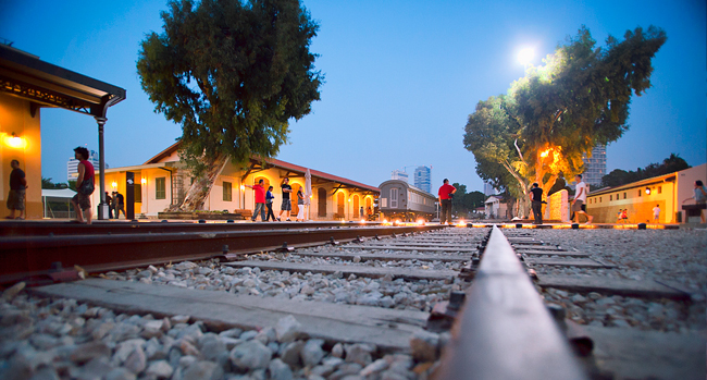
But both train stations, especially the depot in Jerusalem are cultural centers as well as train stations.
First Train Station, Jerusalem
My family and I have attended a film festival, a book fair and and several concerts in the First Train Station.
Beit Shemesh train station looking east
Railroad service was first proposed for the land of Israel by Moses Montefiore in the 1830’s. At that time travel within the land of Israel was by foot or by camels. The trip to Jerusalem was long and hard.
Bet Shemesh Train Station looking North
The route a ride from the port city of Jaffa crossed the Plain of Sharon from the port of Yafo to Lod (or Lydda).
Beit Shemesh city sign
Then the road entered the Sorek Valley, ascending to Beit Shemesh.
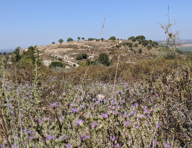
Zorah is on this Mountain
This is the land of Samson and Delilah.
Farmland approaching Beit Shemesh
Beit Shemesh is listed as a city both in the territory of Dan and in the Judean Hill country.
Judean Hills - Zorah in background
The train ascends the Judean hills along the sorek river.
Sorek River running through the Judean Hills
The ride is very beautiful. There are some olive groves along the way,
Olive Groves along Railroad Line
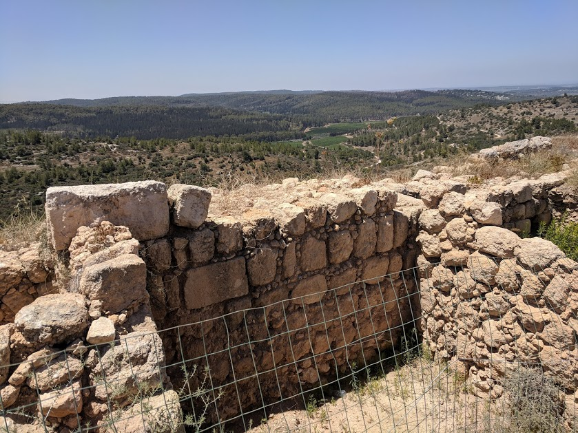
But not many houses, for this is rugged country.
Defensive Structure in Judean Hills
I was advised many times not to take the train, because the ride from Jerusalem to Beit Shemesh on the train takes longer than a bus ride. (about an hour) To get from the train station in Beit Shemesh to the airport requires three or four train transfers.
Old Railroad leaving Jerusalem Highlands
We were not taking the ride to meet a time schedule, only to see the beauty.
Beauty from train window
The train was for the most part empty because of people’s attitudes. That was ok for us, as we could take pictures from both sides of the train through the windows.
Train from Jerusalem to Beit Shemesh
Near the top of the hill the train stops at a terminal across the street from the Biblical Zoo.
Looking across tracks from Biblical Zoo in Jerusalem
The final stop is near German Colony.
Looking at park behind Jerusalem Train Station
We enjoyed the smooth and beautiful ride very much.
Map of Israel Train zones

In the near future there will be a high speed train from Jerusalem to the airport. Don’t know, but possibly train service on the old line will come to an end at that time.

Wednesday, June 6, 2018

A visit to the top of Mount Scopus

Today we went to the top of Mount Scopus and visited Hebrew University.
Jerusalem from the top of Mount Scopus
At 2710 feet above sea level, Mount Scopus is the highest mountain near Jerusalem and it therefore offers a great view of the city.
The view of Mount Scopus from the Mount of Olives
Mount Scopus is the highest peak along the ridge that is also known as the Mount of Olives.
Looking at Jerusalem
The name of the peak means “watcher.” Since antiquity people have climbed the mountain to scope out what is occurring in Jerusalem.
Looking at Jerusalem from Hebrew University
In 1918, Zionist leaders laid a cornerstone as a promise to build a place of higher learning on top of Mount Scopus. The school opened in 1925.
Looking down from Hebrew University
After Israel was created in 1948, the mountain became part of a United Nations zone of protection within Jordanian territory. At times Mount Scopus, with it’s school, was totally cut off from the outside. Men and women dedicated to the institution of higher learning on it’s peak protected the school by offering their continual presence.
A Plaza at Hebrew University
We took the bus up Mount Scopus for our visit to the University.
Looking up to Mount Scopus from the wall around Jerusalem
When we arrived on campus, we stepped out to one of the overlook plazas on the campus. The campus is large and an easy place to get lost. Various buildings are attached and dedicated to various disciplines. Other buildings are across open plazas, or on the eastern descent of the mountain.
Map of Hebrew University
After taking pictures we walked to the east side of the mountain and visited The National Botanic Garden of Israel.
The Garden at Hebrew University
This garden was started by one of the professors of Biology with the goal of planting and maintaining every plant native to the land of the Bible.
How the Garden Started
The gardens are diverse, containing everything from water plants
Water Plants at Hebrew University
(look closely, can you count the frogs??)
Frogs on the Lily Pad
To plants of the Negev.
Plants of the Negev
The garden also contains tombs dating back to the times of the New Testament and before.
First Century Tombs around Jerusalem
A Jewish man named Nicanor of Alexandria, who donated the beautiful (Acts 3) bronze Eastern Gate of Herod’s Temple is buried in this graveyard.
First Century Tombs and Osuary
The gardens extend throughout the University,
Plants on Mount Scopus
With Tabachnik Garden, a National Park, located below the University on the southern slopes of Mount Scopus.
School of International Studies
We walked the campus, and saw the International School, in the Frank Sinatra building.